
St Martin'sCE Primary School
Geography
Inspiring every child to understand the world, their place within it and how people and environments are connected.
Our vision
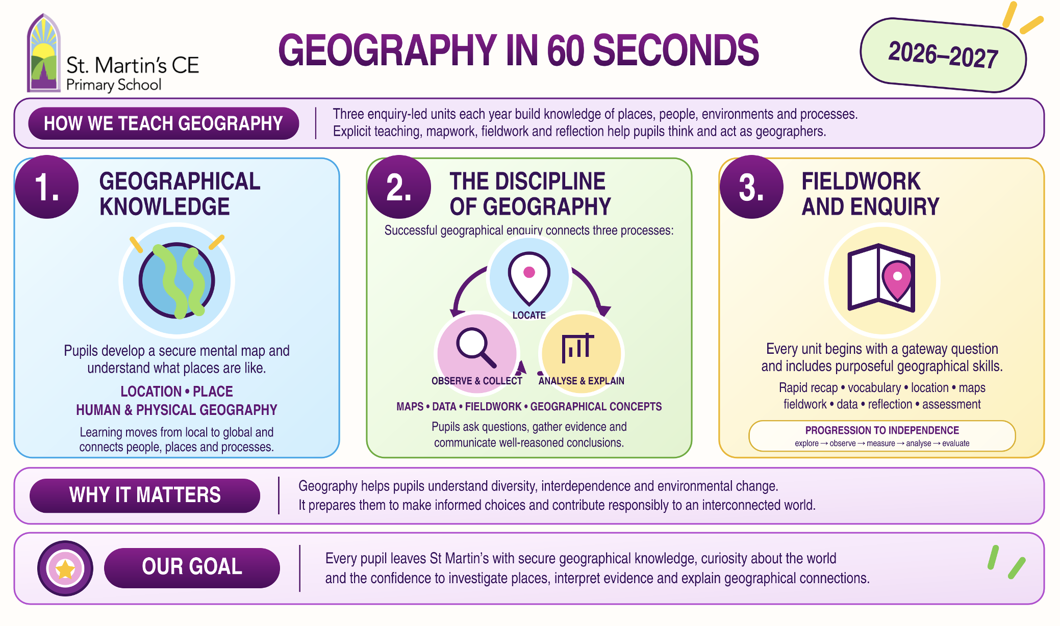
At St Martin's, geography is ambitious, inclusive and rooted in enquiry. Pupils build secure knowledge of places, environments and processes at local, national and global scales. They learn to think geographically, use maps and data confidently, investigate through fieldwork and explain the connections between people, places and the natural world.
A coherent curriculum for our school
Pupils study three geography units each year. Every unit is guided by a gateway question that gives learning a clear purpose and prevents topics from becoming overly broad. Our spiral curriculum revisits essential knowledge, skills and concepts in increasingly demanding contexts so that pupils remember more, connect ideas and apply their learning with growing independence.
What pupils learn
Our curriculum is organised through the four interconnected strands of the National Curriculum:
- Locational knowledge – knowing where places and features are and developing a secure mental map of the world;
- Place knowledge – understanding what places are like and how their physical and human characteristics make them distinctive;
- Human and physical geography – explaining the processes that shape environments and influence how people live; and
- Geographical skills and fieldwork – using maps, atlases, globes, digital mapping, data and first-hand investigation.

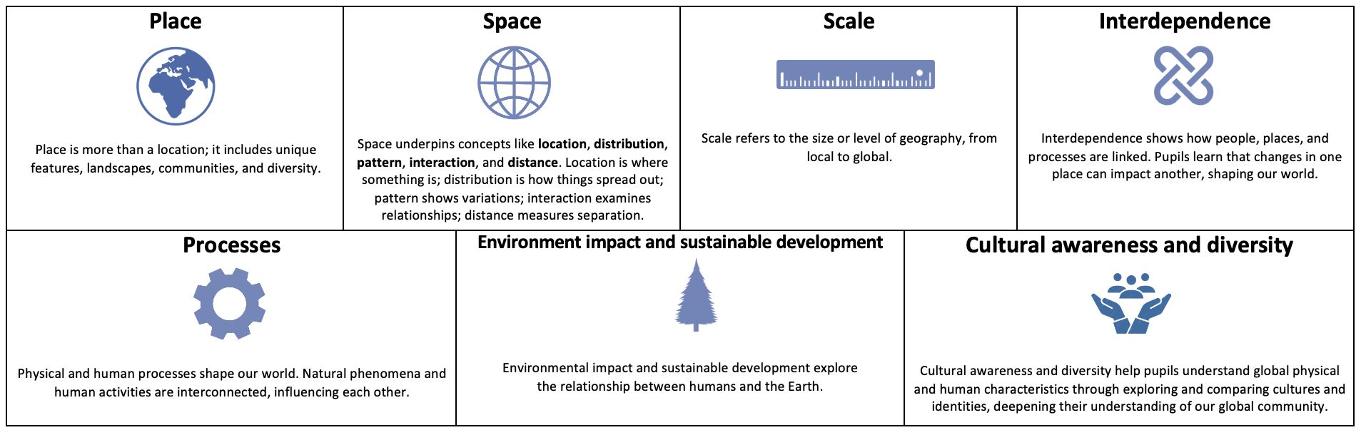
Knowledge is connected through recurring geographical concepts: Place, Space, Scale, Interdependence, Physical and Human Processes, Environmental Impact and Sustainable Development, and Cultural Awareness and Diversity. These ideas help pupils recognise patterns and relationships across different topics and scales.
How geography is taught
Geography is taught in carefully planned blocks. A typical lesson includes:
- a rapid recap that retrieves earlier knowledge and helps teachers identify what pupils remember;
- an enquiry question and a clear geographical concept;
- explicit teaching of Tier 3 vocabulary and its meaning;
- location work so pupils know where their learning sits within the world;
- rich geographical knowledge alongside purposeful mapwork, data, sources or fieldwork; and
- reflection on how the learning has helped pupils become better geographers.
Knowledge organisers identify the essential knowledge and vocabulary for each unit. Carefully chosen maps, photographs, texts, datasets, school trips and visiting experts deepen understanding and help pupils apply what they know.
Fieldwork and geographical enquiry
Fieldwork is a central part of our curriculum rather than an occasional activity. Pupils observe, measure, collect, record, present and interpret geographical information. Their skills become increasingly sophisticated, progressing from exploration and simple observation to selecting suitable methods, evaluating data and completing an independent enquiry in Year 6.
Challenge and progression in mixed-age classes
Pupils in mixed-age classes explore the same gateway question, which supports shared discussion and meaningful enquiry. However, teachers use the progression documents to select age-appropriate knowledge, geographical concepts and disciplinary skills for each year group. This secures National Curriculum coverage, prevents unnecessary repetition and ensures that older pupils deepen, explain and apply rather than simply repeat earlier work.
Diversity, belonging and inclusion
Geography reflects the diversity of our school community and helps pupils understand themselves, Salisbury, Britain and the wider world. Pupils compare places and experiences, consider different perspectives and explore how geography influences culture, opportunity and daily life. Learning about interdependence, environmental impact and sustainability encourages pupils to consider how choices made in one place can affect people and environments elsewhere.
All pupils, including those with SEND and pupils learning English as an additional language, study ambitious geographical content. Teachers adapt explanations, vocabulary teaching, resources, scaffolds and methods of recording so that pupils can participate successfully while maintaining the intended geographical knowledge and thinking.
How do we know pupils are learning?
Assessment is woven through teaching and is used to improve learning. Teachers:
- use pupils' first response to the gateway question to identify prior knowledge and misconceptions;
- check recall through rapid recaps and revisit knowledge in later lessons and units;
- assess pupils' explanations, use of vocabulary, maps, data and fieldwork evidence;
- use year-specific expectations to judge progress within mixed-age classes;
- use pupil conferencing to check retention and attitudes towards geography; and
- return to the gateway question at the end of the unit so pupils can show how their understanding has deepened.
The intended impact is that pupils retain coherent geographical knowledge, make connections across places and scales, use geographical evidence confidently and understand their responsibilities within an interconnected world.

.jpeg?v=1789940231)
.jpeg?v=1789940231)
Curriculum documents
For further detail, please see our Geography Curriculum Statement, Geography Long-Term Map and Big Ideas, and Geography Progression document.